When the fields turned brown, the city appeared
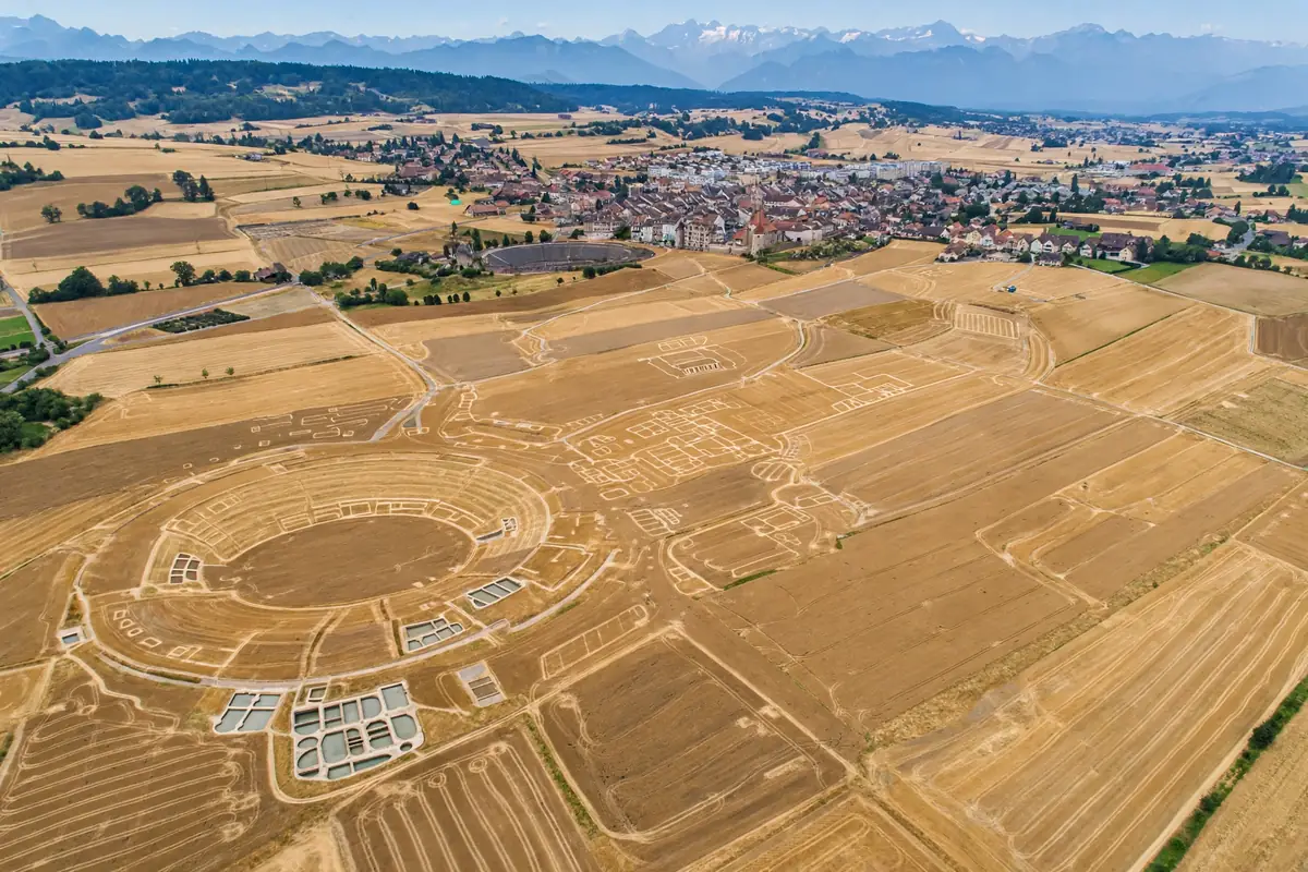
Switzerland has just endured the hottest summer on record, and the heat has rewritten the country's Roman history. As fields around the small town of Avenches withered in the drought, ghostly outlines began to appear in the crops — the buried walls of Aventicum, the former capital of Roman Helvetia, founded 2,000 years ago after Julius Caesar's defeat of the local tribes. On 29 September, Reuters reported that archaeologists are now redrawing the Roman maps of Switzerland on the strength of what the parched earth revealed.
The mechanism is one archaeologists know well: "parch marks". Where stone walls lie buried, the soil above them is shallower and dries faster; in a drought, the vegetation growing over walls withers and browns while crops over deeper soil stay green. From the ground the effect is invisible. From a drone, the buried city draws itself.
A tip from a history enthusiast
The discoveries began, fittingly, with an amateur's sharp eyes. Alerted by a history enthusiast, archaeologists in the canton of Vaud flew a drone over the fields around Aventicum day after day from June to August, capturing the parch marks as they emerged and shifted with the heat. A team of five archaeologists then superimposed the traces onto the existing maps in purple — filling in blank spaces and correcting mistaken markings.
What the images revealed was remarkable: traces of thermal baths, houses, roads and a possible temple, many of them previously unknown or only dimly understood, and many lying in areas of the ancient city that have never been excavated. Jordan Anastassov, the archaeologist for the canton of Vaud, told Reuters: "These are the richest discoveries made there in the last 50 years, at least over the last two generations of archaeologists."
"These are the richest discoveries made there in the last 50 years, at least over the last two generations of archaeologists." — Jordan Anastassov, archaeologist for the canton of Vaud, speaking to Reuters
A capital of Roman Switzerland
Aventicum was no provincial backwater. As the capital of the Helvetii under Rome, it was a substantial city — with an amphitheatre, a theatre, grand baths and a forum — thriving under Roman rule for centuries before gradually fading as Germanic incursions increased from the third century onward. Today it is the small town of Avenches, its Roman past visible in standing monuments and a museum, but with much of the ancient city still sleeping under farmland.
That is what makes the drought finds so significant. Excavation is slow, expensive and destructive; archaeologists can only open small windows into a buried city. The parch marks, by contrast, offered something close to a plan view of whole districts at once — including zones no trowel has ever touched. The new traces are already prompting fresh questions about the city's layout, as archaeologist Hugo Amoroso put it: "We are now asking really interesting questions we wouldn't otherwise be asking."
"We are now asking really interesting questions we wouldn't otherwise be asking." — Hugo Amoroso, archaeologist, speaking to Reuters
Fleeting traces, lasting maps
The evidence was as ephemeral as it was rich. Some of the traces captured between June and August vanished after fields were mowed and temperatures fell; parch marks are, by nature, a collaboration between buried stone, stressed crops and a particular week of weather. But as unseasonably warm weather persisted into September, the perimeter of a new pool in the baths complex was still visible in a partially withered alfalfa field — a Roman swimming pool, of sorts, reappearing after some 1,700 years.
That fleeting quality is why the drone survey mattered. Without the daily flights, the summer's revelations would have come and gone unrecorded, visible only to whoever happened to look down at the right moment. The team's purple-inked maps preserve what the drought disclosed.
A summer of surfacing history
Aventicum was not the only place where the record heat pulled the past to the surface. The same heatwaves exposed Second World War wrecks on riverbeds as water levels fell, and other buried historical remains have emerged elsewhere in Switzerland and Europe. Many of those, the Vaud team notes, are harder to interpret — isolated traces without dedicated researchers to read them. Aventicum is fortunate in having both: a known city beneath the fields and a team ready to map it.
The Swiss archaeologists will present their findings to their peers and may follow up with targeted excavations — small, precise digs to ground-truth what the parch marks suggest. In the meantime, the maps of Roman Switzerland have already changed: blank spaces filled, old errors corrected, and a buried capital a little less buried than before.
There is a quiet irony in it. Aventicum faded, in the end, because the world around it changed — the empire's grip loosened, the Germanic peoples pressed in, and the city shrank into a town. Two thousand years later, it took a changing climate to bring the city back into view. The heat that stressed Switzerland's farms also handed its archaeologists the richest discovery in two generations — a reminder that the ground beneath our feet is an archive, and that sometimes it opens itself.
Reading a field like a document
Aerial archaeology is nearly a century old — pilots after the First World War noticed that ancient earthworks showed up in photographs — but the Vaud survey shows how the technique has matured. Flying the same fields daily for three months turned a momentary phenomenon into a dataset: the team could watch individual marks strengthen, fade and reappear with the weather, separating genuine buried structures from the noise of modern field drains and ploughing.
The approach also reflects a shift in archaeological ethics. Excavation destroys as it reveals; a trench, once dug, can never be undug. Non-invasive survey — drones, geophysics, parch-mark mapping — lets archaeologists read a site without touching it, reserving excavation for the precise questions only digging can answer. The purple-inked maps of Aventicum are the product of that philosophy: a fuller plan of the buried city, produced without moving a single stone, in a summer when the climate did the revealing.
Sources